Wednesday, January 17, 2018

Meeting Meg

It was 30°C and crowded in Queenstown; I needed to get out. Plans for my days off had fallen through so the morning had been spent poring over maps and trawling the internet for ideas. While I was sceptical that the forecast heavy rain would actually reach this drought stricken area, I still wanted to avoid any stream crossings which could become dicey. I also wanted a sense of freedom and wide open space. So eventually I settled on Meg Hut in the Pisa Range. 

But 30°C was far too hot to contemplate climbing for two hours up the arid, treeless hills so I while away the heat of the day lounging under a tree in Arrowtown, contentedly slurping a thickshake. By the time I set of from the Cardrona Valley on Shanks' pony there was high cloud cover and a breeze, making it merely quite warm rather than absolutely roasting. Even so, within minutes my drinking water turned disgustingly tepid. 


The track is a farm road through Waiorau Station which climbs over 500m up to Tuohys Saddle before dropping down to the headwaters of the Roaring Meg. There was evidence of a recent massacre: shotgun pellets and rabbit carcasses were strewn about, although there were plenty of live bunnies still nonchalantly hopping about. Grasses and farm weeds gradually gave way with altitude to tussock and Spaniards. 

Built in the 1860s as a musterers' hut, with extensions and upgrades through the twentieth century, Meg Hut has been restored by DOC and is quite spacious and tidy inside. Despite the hut being unoccupied I opted to pitch my tent as I hadn't field tested it yet. 


It was a delightfully peaceful spot, with a backdrop of rocky tors and the gentle murmuring of the brook. The perfect place to relax for a couple of nights away from the summer crowds.

Monday, January 15, 2018

Steele Creek

"It is not a shortcut". Thus proclaims the information sheet at Mid Caples hut. On the map Steele Creek looks like a nice shortcut between the Caples and Greenstone valleys, but it has a reputation of being difficult and demanding. The treasurer of the local Deerstalkers Association had similarly warned me not to underestimate Steele Creek. To top it off I met a young Scotsman who did the route ten years ago and swore "Never again!" Now, after having just completed the trip again he vowed "Definitely never again!" Of course, the more I heard the more I wanted to go over Steele Creek. 

From Upper Caples hut the 850m climb is steep and relentless, but straight forward. I was glad to be going up this section rather than descending. The bushline was reached in a tad under two hours and I paused to slather on sunblock. From the bushline the route is marked with warratahs but the foot track quickly became obscure. It began by following thin scree channels through low scrub before edging along tussock southwest toward the pass. A damp ledge lead to the broad pass at 1359m.


Below me was revealed the vista of Steele Creek running nearly due south to the Greenstone valley. Six kilometres away, at the end of river flats, the bright speck of Steele Creek Hut was just visible. The way down was again marked with warratahs and only a faint ground trail, although that became more defined as tussock gave way too low scrub. The going was easy until around the 1150m contour, where the scrub got thicker. Route finding simply became finding the path of slightly less resistance. That said, as far as scrub goes it was pretty light and not onerous. Entering into the beech forest at the foot of Tongue Spur provided welcome shade and a clear track. The final 2km down the extensive gravel flats were straight forward; simply keep walking in a straight line. A large cairn marked the southern end of the flats, and a couple of minutes later an orange marker pointed up the river bank to the hut.


Steele Creek Hut is an historic hut which was restored several years ago by the Deerstalkers association and DOC. The framing is beech saplings, with iron cladding and a dirt floor. Thankfully the upgrades included new beds, so no sacking bunks tonight.

Was it a shortcut? No (unless you define 'shortcut' as the longest time between two points), but it sure was far more interesting. Steele Creek is simply a good old tramping route requiring basic routefinding skills and a reasonable level of fitness. Its difficulty gets talked up because it is surrounded by well-defined, well maintained tracks which are achievable for Joe Bloggs off High Street. For the average punter on the Greenstone Caples circuit, yes, Steele Creek would be well out of their depth. But for me? I couldn't have enjoyed it more!

Friday, December 8, 2017

Kay Creek

From the upper Caples Valley, Kay Creek runs NNW up into the Humboldt Mountains. The creek itself is mostly bouldery, with a couple of shingle flats. It is a beautiful stream, full of charm, and there are delightful views up and down the valley. 


After cutting the corner from the Fraser Creek turnoff the route heads up the true right of the valley. The first 100m of altitude is gained quickly but thereafter the ascent is gradual. The track itself is well marked but hasn't been cleared for a while so there is a bit of windfall and debris to contend with. After crossing the initial shoulder from the Caples the track stays pretty close to Kay Creek for the rest of the way. Part way along the main clearing a large, active slip comes down to the creek and the path becomes indistinct. In low flows it is possible to skirt around the slip at water's edge. Cairns and track markers show the way up the rest of the clearing, and there are numerous little streams to be forded on the shingle flats. As Death Valley nears the track heads uphill on the true left of Kay Creek - a sure sign the hut is not far away. With the hut in sight there is one final crossing of Kay Creek to be done. The ford is in a steep and bouldery spot which could be dicey if the stream is up*.


Kay Creek Hut is an old, dirt-floored four bunk hut. It was given a spruce up in 2016 by the Otago University P.E. department and now looks quite cosy. Judging by the hut book it is seldom visited (except by the uni groups), with most parties either hunting or heading over into Scott Creek and the Routeburn Road (or reverse).


It took me 2:40 hours to cover the 6km from Upper Caples Hut with a light day pack and no breaks. I thoroughly enjoyed the rough state of the track - it was nice to have a sense of wilderness after the wide easy path along the Caples. Kay Creek would have to be my favourite excursion of the summer so far!


* According to a note in the hut book, if water levels are high it is safer to cross Death Valley stream by the hut, instead of Kay Creek, and continue down the true right until the track is picked up. 


Thursday, November 16, 2017

Earnslaw Burn


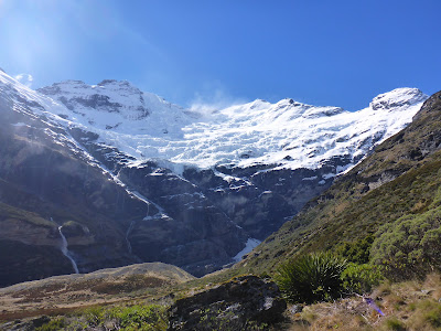
Earnslaw Burn is a wee valley draining the southern aspect of Mt Earnslaw/Pikirakatahi (2,830m). The start of the track is a little hard to find as there are no signs and it is marked incorrectly on old maps. Turn down Lovers Leap Rd (off the road to Paradise), and when the road does a sharp right turn look across the paddocks to the left and you will see an orange triangle. The track sidles up the valley through beech forest for four hours, staying roughly 100m above the stream. It is not particularly interesting, with only one or two views and no glimpses of the river until nearly at the bushline. The rewards come once you emerge into the delightful alpine basin with a babbling stream, lovely flats and waterfalls pouring over majestic flats. There is a rock bivvy, complete with wooden sleeping platform, on the true right of the stream at the bushline and another about 500m further upstream under cliffs on the true left. As you wander up the valley the vista only gets more spectacular as the Earnslaw Glacier comes into view. There are plenty of excellent camping spots and boulders which would give some shelter. I bivvied under a rock near the head of the valley at the base of Lennox Pass. It would have to be one of the most majestic I have ever slept!


I returned back the way I came, but a good alternative is to head up onto the tops from the first stream below the bushline and follow the ridge to Lovers Leap and down to the car park.

Monday, September 25, 2017

NZAC Girls Trip

The Auckland Section of the New Zealand Alpine Club organised a girls only trip to Mt Ruapehu, and last weekend found 10 ladies ensconced at the NZAC Ruapehu Hut at Delta Corner near Knoll Ridge CafĂ©. The objective was to walk up to the top of Pyramid (2,645m), one of Ruapehu's 12 peaks, but mainly to simply enjoy being on the mountain.


Three of us took the Friday off work to travel down and so managed to catch the last chair lift up the ski field - the others didn't arrive until about 2am! The afternoon was ridiculously warm with blue skies and a touch of lightly falling snow. Having skipped the walk up to the hut, I made myself useful and got some exercise digging out the fire exit.


Saturday morning was clear but a little breezy so I got up at 6am to watch the sunrise. The sky was clear all the way out to Mt Taranaki in the west, and the rosy light gradually crept over its slopes as it emerged from the shadow of Ruapehu. The late arrivals didn't emerge from bed until a while later, so it was just after 8am when we began wandering upwards. We opted to go up the gut and through the notch onto the Summit Plateau, where we were sheltered from the worst of the wind. There was blue sky all the way until we reached the southern corner of the plateau where we paused to regroup before heading over to Pyramid. I could see the peak with cloud billowing in front, but by the time everyone had caught up we were encased in cloud with almost zero visibility. Occasional clearances allowed us to find our way over to the north ridge of Pyramid, which we followed to the top. Despite being directly above the crater lake we didn't see it at all! It was cool and breezy on top so we only stayed long enough to take a few summit shots before retreating to a sheltered spot for lunch. Then it was simply a matter of retracing our foot prints back to Whakapapa. Some of us had hoped to traverse the ridge along to Te Heuheu, but decided it wasn't worth it in the wind and limited visibility. As we went through the notch and headed down toward the ski field we dropped below the cloud and once again had a view. Back at the hut in time for afternoon tea after a leisurely 6 hour stroll.


I poked my head out of the door at first light on Sunday to be greeted by a wet shroud of white and a blustery breeze. Oh well, back to bed. It wasn't worth trying to climb anywhere in the rain and wind so we simply packed up and walked down to the cars.

Sunday, July 9, 2017

Mt Arthur Mission

A quick, spur of the moment dash up Mt Arthur (1,795m) with a friend and friends of friends.

Driving across the Moutere Valley we could see the peak of Mt Arthur bathed in sunshine above a layer of cloud. This cloud promised to lift, and as we swiftly marched up the track from Flora car park we had sunny spells and glimpses of the surrounding country. Unfortunately the cloud only lifted to about 1,700m and the summit remained swathed in cloud.


There was a bit more snow than we were expecting which made it fun. The only really sketchy bit was traversing above a gully just after the Winter Peak turn off - the run out was awful! A couple of our party were in running shoes and I was the only one with an ice axe. We made it safely across but then met a couple descending who told us that the last little bit was trickier. Only two of us pushed the last 5 minutes to the summit as the others decided that they had come high enough without proper gear. A quick retreat off the mountain in thickening cloud saw us back at the car with plenty of daylight to spare.

A marvellous little adventure!

Familiar view on the summit!

18km, 5:20 hours return to Flora car park. (2:50 hours to summit)

Solo to Starveall

It was 0°C when I set off mid-morning from the Aniseed Valley car park in the Richmond Ranges. Pretty cold for the first couple of kilometres along Hacket Creek! (Later I heard this section referred to as "Polar Mile"). I was wearing shorts and my quads were soon red and numb. It took 1 1/2 hours to reach Hacket Hut, which was serenely situated in a sunny clearing. After a quick break it was 30 minutes and 8 river crossings up Hacket Creek, all of which I managed to tiptoe across with dry feet, before beginning the relentless 900m climb. My pack felt pretty heavy! I chugged up the hill steadily; there was no rush and I had the world to myself.

I popped out at Starveall Hut after 4:40 hours and 1,140m of ascent. A hunter (Phil) and his dog (Molly) were already in residence but there was plenty of space to spare in the cosy 6 bunk hut. The tap had broken off the water tank so I had to climb up on top and scoop water out with a billy into a 20L container. Nearby Pt 1258 provided a spectacular vantage point with panoramic views of Mt Rintoul, Abel Tasman and the Arthur Range. There was not a breath of wind so I spent well over an hour soaking up the serenity. Returning to the hut for a hot soup, I was soon back out to watch the brilliant orange sun slowly sink behind the silhouetted shoulder of Mt Arthur. The evening was spent sitting in front of the fire spinning yarns. Phil regaled me with hunting stories and tales of his time trekking in Nepal.

Sunset behind Mt Arthur

Watched the sunrise then headed over Mt Starveall (1,511m) to Slaty Hut. There was a bit of powdery snow around on the tops which was good fun. There was no time pressure as I had all day to fill in so I took my time and had plenty of stops. Two hours through to Slaty Hut, and then I carried on along the track and popped up to Slaty Peak (1,544m). I lingered here in the sunshine for a while before deciding that it was time to get a move on as cloud was spilling over Starveall. Instead of backtracking I continued north then east along the ridge to pick up the track where it entered the bush. The temperature dropped a bit once I entered the cloud, but there was no wind so it was actually quite pleasant. Picking my way down rocks coming off Mt Starveall my foot slipped and I took a small chunk of skin off my hand - nothing a plaster couldn't fix. It was still early in the afternoon when I arrived back at Starveall Hut so I spent a while mucking around gathering firewood etc. There was a pile of logs where a tree had been cleared down the bank so I lugged those up to the wood shed. Cloud came in even thicker at 3:30pm with light showers and a few pellets of hail; the temperature plummeted to 4°C. I was alone for the night, basking in the warmth of the fire.

Slaty Peak
Woke up refreshed after a good long sleep. Packed up efficiently and lugged more firewood to the woodshed before setting off down the hill. The hut was in cloud but I soon dropped down below. I moved steadily, only stopping for photography. For over a kilometre a friendly fantail kept me company, darting around my legs and often approaching within a few inches. He left me at the second to last river crossing. It took 2 hours to reach Hacket Creek and then another half hour through to Hacket Hut. Once again I managed to tiptoe my way across all 8 stream crossings with dry feet. All that remained was a pleasant stroll out to the car park.
Starveall Hutt

Map


I couldn't trace the origin of the name Starveall in the region, but it seems to be a common English farm name implying poor land which is certainly apt.